国立情報学研究所 - ディジタル・シルクロード・プロジェクト
| |||||||||
|
| Serindia : vol.3 | |
| セリンディア : vol.3 |
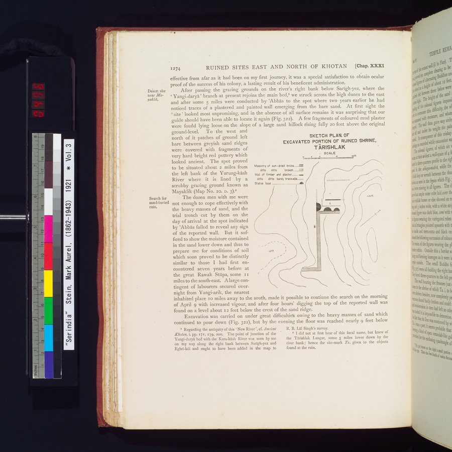 |
| 祀堂跡の発掘済み部分の平面図スケッチ、タリシュラク(TĀRISHLAK)SKETCH PLAN OF EXCAVATED PORTION OF RUINED SHRINE, TĀRISHLAK |
1274 RUINED SITES EAST AND NORTH OF KHOTAN [Chap. XXXI
effective from afar as it had been on my first journey, it was a special satisfaction to obtain ocular proof of the success of his colony, a lasting result of his beneficent adtninistration.
After passing the grazing grounds on the river's right bank below Sarigh-yez, where the ` Yangi-darya' branch at present rejoins the main bed,6 we struck across the high dunes to the east
and after some 5 miles were conducted by `Abbas to the spot where two years earlier he had noticed traces of a plastered and painted wall emerging from the bare sand. At first sight the `site' looked most unpromising, and in the absence of all surface remains it was surprising that our guide should have been able to locate it again (Fig. 322). A few fragments of coloured mud plaster were foutid lying loose on the slope of a large sand hillock rising fully 20 feet above the original
ground-level. To the west and north of it patches of ground left bare between greyish sand ridges were covered with fragments of very hard bright red pottery which looked ancient. The spot proved to be situated about 2 miles from the left bank of the Yurung-kash River where it is lined by a scrubby grazing ground known as Mayaklik (Map No. 20. D. 3).6
The dozen men with me were not enough to cope effectively with the heavy masses of sand, and the trial trench cut by them on the day of arrival at the spot indicated by `Abbas failed to reveal any sign of the reported wall. But it sufficed to show the moisture contained in the sand lower down and thus to prepare me for conditions of soil which soon proved to be distinctly similar to those I • had first encountered seven years before at the great Rawak Stutpa, some I 1 miles to the south-east. A large contingent of labourers secured overnight from Yangi-arik, the nearest
inhabited place 10 miles away to the south, made it possible to continue the search on the morning of April 9 with increased vigour, and after four hours' digging the top of the reported wall was found on a level about 12 feet below the crest of the sand ridge.
Excavation was carried on under great difficultiés owing to the heavy masses of sand which continued to pour down (Fig. 321), but by the evening the floor was reached nearly 9 feet below
SKETCH PLAN, OF
EXCAVATED PORTION OF RUINED SHRINE, T ARISHLAK
SCALE
q 7 0 Lott.
Masonry of sun-dried bricks __MI
ditto ditto broken....__ =
Wall of timber and plaster___....
ditto ditto barely traceable_.:::
Statue base
.:oft.
//.;%%%~Jf •-:
Regarding the antiquity of this `New River ', cf. Ancient Khotan, i. pp. x71, r 79, 20o. The point of junction of the Yangi-daryâ bed with the Kara-lash River was seen by me on my way along the right bank between Sarigh-yez and Eghri-köl and ought to have been added in the map to
R. B. Lai Singh's survey.
e I did not at first hear of this local name, but knew of the Tarishlak Langar, some 5 miles lower down by the river bank; hence the site-mark Ta. given to the objects found at the ruin.
Desert site near Mayaklik.
Search for sand-buried ruin.
|
Copyright (C) 2003-2019
National Institute of Informatics(国立情報学研究所)
and
The Toyo Bunko(東洋文庫). All Rights Reserved.
本ウェブサイトに掲載するデジタル文化資源の無断転載は固くお断りいたします。