国立情報学研究所 - ディジタル・シルクロード・プロジェクト
| |||||||||
|
| Scientific Results of a Journey in Central Asia, 1899-1902 : vol.2 | |
| 1899-1902年の中央アジア旅行における科学的成果 : vol.2 |
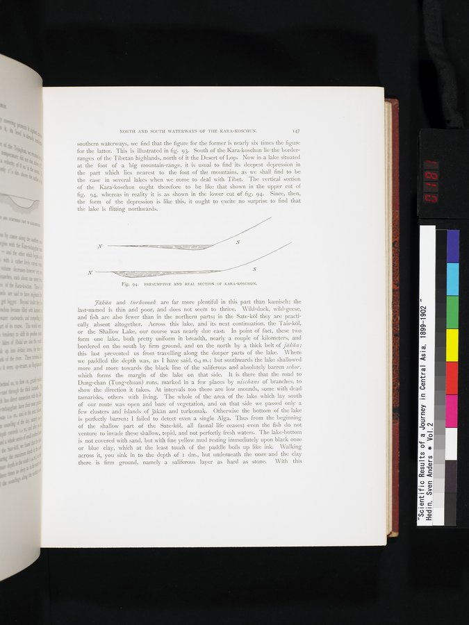 |
| カラ・コシュンの推定断面と実際の断面。PRESUMPTIVE AND REAL SECTION OF KARA-KOSCHUN. |
NORTH AND SOUTH WATERWAYS OF THE KARA-KOSCHUN. 147
southern waterways, we find that the figure for the former is nearly six times the figure for the latter. This is illustrated in fig. 93. South of the Kara-koschun lie the border-ranges of the Tibetan highlands, north of it the Desert of Lop. Now in a lake situated at the foot of a big mountain-range, it is usual to find its deepest depression in the part which lies nearest to the foot of the mountains, as we shall find to be the case in several lakes when we come to deal with Tibet. The vertical section of the Kara-koschun ought therefore to be like that shown in the upper cut of fig. 94, whereas in reality it is as shown in the lower cut of fig. 94. Since, then, the form of the depression is like this, it ought to excite no surprise to find that the lake is flitting northwards.
S
N
Fig. 94. PRESUMPTIVE AND REAL SECTION OF KARA-KOSCHUN.
7äkän and turkomak are far more plentiful in this part than kamisch; the last-named is thin and poor, and does not seem to thrive. Wild-duck, wild-geese, and fish are also fewer than in the northern parts; in the Sate-köl they are practically absent altogether. Across this lake, and its next continuation, the Tais-köl, or the Shallow Lake, our course was nearly due east. In point of fact, these two form one lake, both pretty uniform in breadth, nearly a couple of kilometers, and bordered on the south by firm ground, and on the north by a thick belt of jäkän; this last prevented us from travelling along the deeper parts of the lake. Where we paddled the depth was, as I have said, 0.3 m. ; but southwards the lake shallowed more and more towards the black line of the saliferous and absolutely barren schor, which forms the margin of the lake on that side. It is there that the road to Dung-chan (Tung-chuan) runs, marked in a few places by nischans of branches, to show the direction it takes. At intervals too there are low mounds, some with dead tamarisks, others with living. The whole of the area of the lake which lay south of our route was open and bare of vegetation, and on that side we passed only a few clusters and islands of jäkän and turkomak. Otherwise the bottom of the lake is perfectly barren; I failed to detect even a single Alga. Thus from the beginning of the shallow part of the Sate-köl, all faunal life ceases; even the fish do not venture to invade these shallow, tepid, and not perfectly fresh waters. The lake-bottom is not covered with sand, but with fine yellow mud resting immediately upon black ooze or blue clay, which at the least touch of the paddle boils up like ink. Walking across it, you sink in to the depth of i dm., but underneath the ooze and the clay there is firm ground, namely a saliferous layer as hard as stone. With this
|
Copyright (C) 2003-2019
National Institute of Informatics(国立情報学研究所)
and
The Toyo Bunko(東洋文庫). All Rights Reserved.
本ウェブサイトに掲載するデジタル文化資源の無断転載は固くお断りいたします。