国立情報学研究所 - ディジタル・シルクロード・プロジェクト
| |||||||||
|
| Scientific Results of a Journey in Central Asia, 1899-1902 : vol.2 | |
| 1899-1902年の中央アジア旅行における科学的成果 : vol.2 |
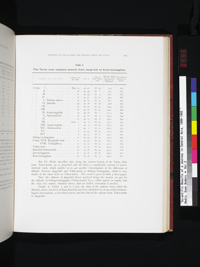 |
| ヤンギ・クルからクム・チャプガンまでのタリム川(西支流)。The Tarim river (western branch) from Jangi-köl to Kum-tschapghan. |
METHODS OF CALCULATING THE HEIGI-ITS AROVE SEA LEVEL. 593
Table 3.
The Tarim river (western branch) from Jangi-köl to Kum-tschapghan.
Name of station.
Lat. N.
Month and day 1900.
Long. E.
from Green-
wich.
Distance along
the river from
Jangi-köl in
kilometres.
Alti`udeabove
sea-level in
metres.
Camp I
II
» III
» IV
V, Bobane-uktusu
VI, Jäkenlik
VII
VIII
IX, Kona-daghilek
X, Satovaldi-köl .
XI
XII
XIII, Ajagh-arghan
XIV, Almontschuk .
XV
XVI
Schirge-tschapghan
Camp XVII, Karghalik-otak .
» XVIII, 'I'schigilik-uj . .
Tokus-atan
Badschit-tschantschdi
Jurt-tschapghan
Kum-tschapghan
May 19 40° 47
20 40 44
2I 40 44
22 40 41
23 40 37
" 24 40 36
27 40 30
28 40 27
29 40 26
»
30 40 18
31 40 I2
June I 40 8
2 40 9
5 40 2
6 39 54
" 8 39 53
» to , 39 45
»
11 39 42
11 39 32 88 23
19 I 39 29
20 39 28
21 39 30
30 - 39 30
15.5 878
22.3 877
28.7 875
44-1 868
65.7 857
74'8 852
104.4 852
143.7 846
171.4 843
192.9 840
209.1 840
251.2 ; 834
263.7 833
286.7 832
322.9 826
333.1 825
373.0 822
383.5 822
417.1 819
423.3 819
431.4 ! 818
492.5 i 817
817
86° 59'
87 2
87 4
87 10
87 23
87 38
87 41
87 50
88 1
88 5
88 8
88 15
88 20
88 21
88 23 88 2I 88 23 88 24
88 24
88 44
88 56
89 4 496.0
But Dr. Hedin travelled also along the eastern branch of the Tarim delta from Tokus-tarim up to Jangi-köl and did there a considerable amount of hydrometrical work, which enables us to get another determination of the difference of altitude between Jangi-köl and Tokus-tarim or Schirge-Tschapghan, which is very nearly at the same level as Tokus-tarim. The result is given in table 4 (next page).
Now the altitude of Jangi-köl above sea-level being 881 metres, we get for the altitude of Schirge-tschapghan (Tokus-tarim) 823.3, which agrees so nearly with the value 822 metres, obtained above, that no further correction is needed.
Finally in Tables 5 and 6, I give the data of the stations from which the altitudes above sea-level of Kara-koschun has been calculated by means of the meteorological observations, as described above, and the data of the stations from Tokus-tarim to Jangi-köl.
|
Copyright (C) 2003-2019
National Institute of Informatics(国立情報学研究所)
and
The Toyo Bunko(東洋文庫). All Rights Reserved.
本ウェブサイトに掲載するデジタル文化資源の無断転載は固くお断りいたします。