国立情報学研究所 - ディジタル・シルクロード・プロジェクト
| |||||||||
|
| Scientific Results of a Journey in Central Asia, 1899-1902 : vol.2 | |
| 1899-1902年の中央アジア旅行における科学的成果 : vol.2 |
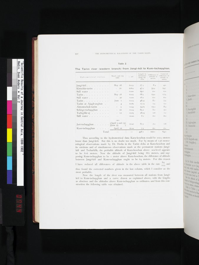 |
| ヤンギ・クルからクム・チャプガンまでのタリム川(西支流)。The Tarim river (western branch) from Jangi-köl to Kum-tschapghan. |
592 THE HYPSOMETRICAL RALATIONS OF THE TARIM BASIN.
Table 2.
The Tarim river (western branch) from Jangi-köl to Kum-tschapghan.
Month and day
1900.
s. 1o3.
Length in kilometers along the river.
Difference of Corrected
altitude in difference of
meters. altitude iu.
meters.
Hydrometrical station.
Jangi-köl
Kirtschin-tarim
Still water
Tarim
Still water
Tarim
Tarim at Ajagh-arghan . Almontschuk-tarim . . Schirge-tschapghan . .
Tschigilik-uj
Still water
May 16 0.233
21 0.829
0.0ô0
0.225 88.5
0.000 16.2
May 28
30
June I
4
5
10
s I2
27.3 • 6.4 4.0
47.5 39 4 24.7
29.6 0 0 0.o
19.9 12.5
0.o 0.0
48.35 8.7 5.5
17.75 I.5 ' 1.0
54.65 1 3 3 8.3
65.2 8.o 5.o
28.25 1.8 I .1
8.i 0.0 0.o
0.173 0.082 0.243 0.I24 0.065 0.000
Jurt-tschapghan
Ku m-tschapghan
Total
1901
April 3 and 13 June 25
April 10
0.047 61.1
O 021 3 5 I
I - I 496 0 I
2.9 1.8
0.1
102.0 64.0
0.I
Thus according to the hydrometrical data Kara-koschun would be 102.o meters lower than Jangi-köl. But this is no doubt too much. For by means of 136 meteorological observations made by Dr. Hedin in the Tarim delta at Kara-koschun and its environs and of simultaneous observations made at the permanent stations Jangiköl and Tscharklik, the probable altitude of Kara-koschun above sea-level appears to be 816 meters. Now the altitude of Jangi-köl being 881 meters, and supposing Kum-tschapghan to be i meter above Kara-koschun, the difference of altitude between Jangi-köl and Kum-tschapghan ought to be 64 meters. For this reason
I have reduced all differences of altitude in the above table in the rate Iô4 and
thus found the corrected numbers given in the last column, which I consider as the most probable.
Now the length of the river was measured between all stations from Jangiköl to Kum-tschapghan and a curve drawn as explained above, with the lengths as abscissa and the altitudes above Kum-tschapghan as ordinates. and from this construction the following table was obtained.
|
Copyright (C) 2003-2019
National Institute of Informatics(国立情報学研究所)
and
The Toyo Bunko(東洋文庫). All Rights Reserved.
本ウェブサイトに掲載するデジタル文化資源の無断転載は固くお断りいたします。