国立情報学研究所 - ディジタル・シルクロード・プロジェクト
| |||||||||
|
| Scientific Results of a Journey in Central Asia, 1899-1902 : vol.2 | |
| 1899-1902年の中央アジア旅行における科学的成果 : vol.2 |
 |
| トスン・チャプガン支流、4月10日。Tusun-tschapghan branch, April 10. | |
| クム・チャプガン支流。4月10日。Kum-tschapghan branch, April 10. |
154
KARA-KOSCHUM.
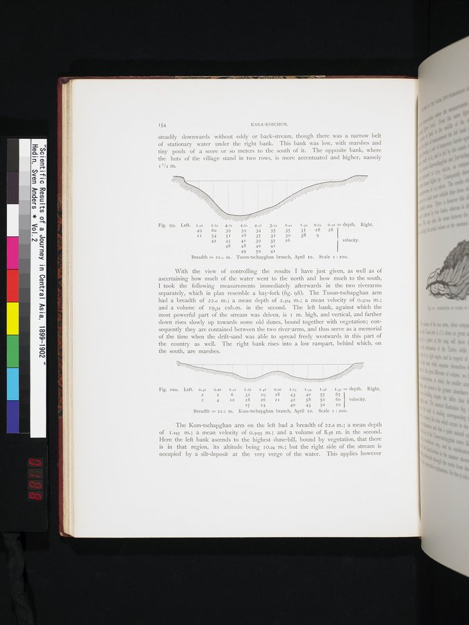
steadily downwards without eddy or back-stream, though there was a narrow belt of stationary water -under the right bank. This bank was low, with marshes and tiny pools of a score or so meters to the south of it. The opposite bank, where the huts of the village stand in two rows, is more accentuated and higher, namely
I I/2 m.
2.87 4.67 4.80 4.36 3.95 2.41 I.3o 0.62 0.16 = depth. Right.
6o 39 39 34 35 35 31 28 28
54 51 28 37 32 30 38 9
42 45 41 39 37 26 ! velocity.
46 4840 41
49 50 41
Breadth = 22.o m. Tusun-tschapghan branch, April Io. Scale I : zoo.
With the view of controlling the results I have just given, as well as of ascertaining how much of the water went to the north and how much to the south, I took the following measurements immediately afterwards in the two riverarms separately, which in plan resemble a hay-fork (fig. 98). The Tusun-tschapghan arm had a breadth of 22.o m.; a mean depth of 2.364 m.; a mean velocity of 0.3729 in.; and a volume of 19439 cub.m. in the second. The left bank, against which the most powerful part of the stream was driven, is 1 m. high, and vertical, and farther down rises slowly up towards some old dunes, bound together with vegetation; consequently they are contained between the two river-arms, and thus serve as a memorial of the time when the drift-sand was able to spread freely westwards in this part of the country as well. The right bank rises into a low rampart, behind which, on the south, are marshes.
Fig. Ioo. Left. 0.46 0.88 I.x6 I.88 I.48 0.86 I.63 I.99 I.96 1.37 = depth. Right.
2 2 6 31 29 18 43 40 57 67
2 4 I0 28 26 2I 42 58 5o 6o velocity.
27 24 40 43 50 10
Breadth = 22.6 m. Kum-tschapghan branch, April Io. Scale I : 200.
The Kum-tschapghan arm on the left had a breadth of 2 2.6 m. ; a mean depth of 1.243 m.; a mean velocity of 0.3055 m.; and a volume of 8.58 m. in the second. Here the left bank ascends to the highest dune-hill, bound by vegetation, that there is in that region, its altitude being 10.24 m.; but the right side of the stream is occupied by a silt-deposit at the very verge of the water. This applies however
Fig. 99. Left. I.o6
49
2I
|
Copyright (C) 2003-2019
National Institute of Informatics(国立情報学研究所)
and
The Toyo Bunko(東洋文庫). All Rights Reserved.
本ウェブサイトに掲載するデジタル文化資源の無断転載は固くお断りいたします。