国立情報学研究所 - ディジタル・シルクロード・プロジェクト
| |||||||||
|
| Scientific Results of a Journey in Central Asia, 1899-1902 : vol.2 | |
| 1899-1902年の中央アジア旅行における科学的成果 : vol.2 |
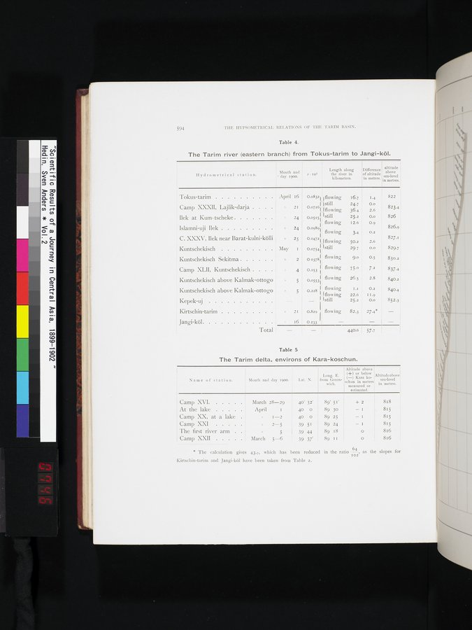 |
| トクス・タリムからヤンギ・クルまでのタリム川(東支流)。The Tarim river (eastern branch) from Tokus-tarim to Jangi-köl. | |
| カラ・コシュン前後のタリム川デルタ。The Tarim delta, environs of Kara-koschun. |
594 THE HYPSOMETRICAL .RELATIONS OF THE 'l'ARIM BASIN.
Table 4.
The Tarim river (eastern branch) from Tokus-tarim to Jangi-köl.
J • rO3
Hydrometrical station.
Month and
day 1900.
Length along
the river in
kilometers.
Difference
of altitude
in meters.
altitude above sea-level in metres.
Tokus-tarim April i6 0.0832 flowing 16.7 1.4
Camp XXXII, Lajlik-darja e 21 0.0716 still 24.7 0.0
flowing 36.4 2.6
Ilek at Kum-tscheke 24 0.0515 still 25.2 0.0 826
flowing 12.6 0.9
Islamni-uji Ilek 2 24 0.0909 826.9:
flowing 3.4 0.2
C. XXXV, Ilek near Barat-kulni-kölli j » 25 0.04721 50
flowing .2 827.1
Kuntschekisch May I 0.0754Ij1 still 50 7 0.0 829.7
29
s 2 0 03781 Î flowing 9.o 0.5 83.3.2
16 0.233 - - -
0.153 ~ flowing 75.o 7.2 837.4
flowing 26.5 2.8 840-2
0.05531' 40 '
0.228 f; flowing 1.1 : 0.2 840.4
}1flowing 22.6 I 1.9
Îstill25.2 O.o 852.3
2I 0.829 fl flowing 82.3 ' 27.4* -
440.6 I 57.7
822
823.4
2.6
Camp XLII, Kuntschekisch . . . 4
Kuntschekisch above Kalmak-ottogo
5
Kuntschekisch above Kalmak-ottogo Y 5
Kepek-uj -
Kirtschin-tarim »
Jangi-köl
Total !
Kuntschekisch Sekitma
Table 5
The Tarim delta, environs of Kara-koschun.
* The calculation gives 43.7, which has been reduced in the ratio -64, as the slopes for
IO2
Kirtschin-tarim and Jangi-köl have been taken from Table 2.
Altitude above
(+) or below
(-) Kara ko-
schun in meters
measured or
estimated.
Name of station. Month and day 1900. Lat. N.
Long. E.
from Green-
wich.
Altitude above
sea-level
in meters.
Camp XVI.
At the lake
Camp XX, at a lake
Camp XXI
The first river arm .
Camp XXII
March 28-29
April I
I-2
2-5
5 March 5-6
40' 32'
40 0
40 0
39 51
39 44
39 37'
89° 51' + 2
89 30 89 25 89 24 89 18 89 II
818
815
815
815
816
816
|
Copyright (C) 2003-2019
National Institute of Informatics(国立情報学研究所)
and
The Toyo Bunko(東洋文庫). All Rights Reserved.
本ウェブサイトに掲載するデジタル文化資源の無断転載は固くお断りいたします。