国立情報学研究所 - ディジタル・シルクロード・プロジェクト
| |||||||||
|
| Scientific Results of a Journey in Central Asia, 1899-1902 : vol.2 | |
| 1899-1902年の中央アジア旅行における科学的成果 : vol.2 |
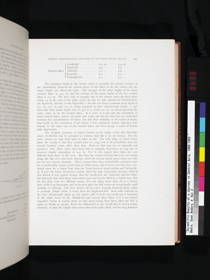 |
GENERAL I-IYDROGRAPHICAL RELATIONS OF THE TARIM DELTAIC REGION. 345
Avullu-köl . . . . . . 6.10 m. 3.92 m.
Tajek-köl 9.52 » 6.50 .
Eastern lakes Arka-köl 7.13 » 5.80 "'
Kara-köl 6 52 » 5.32 »
Tschivilik-köl 5.15 » 4.07 »
The maximum depth in the former series is generally the greater because of the dissimilarity between the eastern shores of the lakes in the two series; but the mean depths are about the same. The average of the mean depths of the three western lakes is 4.73 m., and the average of the mean depths of the five eastern lakes is 5.12 m. We have only to separate out of the eastern series the three lakes which, as in the case of the other series, lie side by side, namely the Tschivilik-köl, the Kara-köl, and the Avullu-Tajek-köl — the last two have a common mean depth of 5.21 m., 3.92 m. and 6.50 m. being regarded as their characteristic depths — and then take their mean depth, and we get as a result 4.87 m., or almost precisely the same value as for the western lakes. In a word, it is not only the orientation of these eastern lakes, drawn out north and south, and the fact that they are embedded between two accumulations of dunes, but also their similarity in the matter of depth, that testify to the correctness of the theory I have advanced, namely that they were formed in the same way as the western lakes, and thus occupy a series of former
bajir depressions.
J P
The frequent presence of mature forests on the banks of the Ilek (Bos-ilek) above Avullu-köl may be accepted as evidence that this is an old stream. For the same reason we may look upon its lakes as old. The only thing we know about them for certain is that they existed prior to 1759; but in all probability they are several hundred years older than that. However that may be, we naturally ask ourselves, how these lakes have been able to maintain themselves so long and to preserve depths amounting to 9.52 m. For in this respect these lakes are very different from those to the west. But then the western (Tarim) lakes are not basins along the line of a river-arm, through which the current merely passes; they are only fed by very narrow channels. These eastern lakes have undoubtedly contained water for a considerably longer period than the Ettek-tarim, and in every case they have contained water for a longer time than the Tarim between Ajagh-arghan and Tschigelikuj. If now the latter stream has entirely filled the bajir depressions through which it first flowed, it may appear strange that the Avullu-köl, the Tajek-köl, and the Arkaköl, although older than those depressions, have not become filled in a similar way. But for this there exist two different causes. For one thing, these lakes lie in a deeper part of the Lop depression, and in the next place the Ilek carries an exceptionally small quantity of sediment. The river derives all its water from the Kontsche-darja, which is perfectly limpid when it issues from the Baghrasch-köl. Such solid material as the river subsequently takes up and carries with it on its way south-east is deposited in the thick reeds of the Maltak-köl and several other lakes, if it is not indeed deposited before it reaches them, so that upon issuing from these lakes the Ilek is again as bright as crystal. From the Maltak-köl to the Avullu-köl its bed is deeply trenched, so that the bright clear water often looks quite black, and for long distances
|
Copyright (C) 2003-2019
National Institute of Informatics(国立情報学研究所)
and
The Toyo Bunko(東洋文庫). All Rights Reserved.
本ウェブサイトに掲載するデジタル文化資源の無断転載は固くお断りいたします。