国立情報学研究所 - ディジタル・シルクロード・プロジェクト
| |||||||||
|
| Scientific Results of a Journey in Central Asia, 1899-1902 : vol.2 | |
| 1899-1902年の中央アジア旅行における科学的成果 : vol.2 |
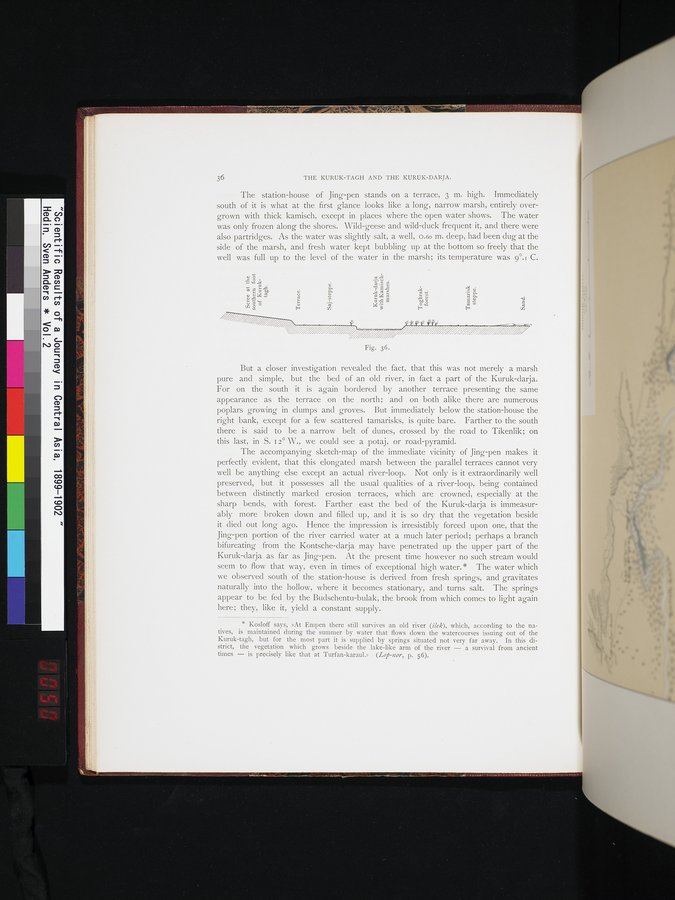 |
| クルク・ダリヤの断面図。Verttcal section of the Kuruk-darja. |
36 THE KURUK-TAGH AND THE KURUK-DARJA.
The station-house of Jing-pen stands on a terrace, 3 m. high. immediately south of it is what at the first glance looks like a long, narrow marsh, entirely overgrown with thick kamisch, except in places where the open water shows. The water was only frozen along the shores. Wild-geese and wild-duck frequent it, and there were also partridges. As the water was slightly salt, a well, o.6o m. deep, had been dug at the side of the marsh, and fresh water kept bubbling up at the bottom so ' freely that the well was full up to the level of the water in the marsh; its temperature was 9°.i C.
But a closer investigation revealed the fact, that this was not merely a marsh pure and simple, but the bed of an old river, in fact a part of the Kuruk-darja. For on the south it is again bordered by another terrace presenting the same appearance as the terrace on the north; and on both alike there are numerous poplars growing in clumps and groves. But immediately below the station-house the right bank, except for a few scattered tamarisks, is quite bare. Farther to the south there is said to be a. narrow belt of dunes, crossed by the road to Tikenlik; on this last, in S. i a° W., we could see a potaj, or road-pyramid.
The accompanying sketch-map of the immediate vicinity of Jing-pen makes it perfectly evident, that this elongated marsh between the parallel terraces cannot very well be anything else except an actual river-loop. Not only is it extraordinarily well preserved, but it possesses all the usual qualities of a river-loop, being contained between distinctly marked erosion terraces, which are crowned, especially at the sharp bends, with forest. Farther east the bed of the Kuruk-darja is immeasurably more broken down and filled up, and it is so dry that the végetation beside it died out long ago. Hence the impression is irresistibly forced upon one, that the Jing-pen portion of the river carried water at a much later period; perhaps a branch bifurcating from the Kontsche-darja may have penetrated up the upper part of the Kuruk-darja as far as Jing-pen. At the present time however no such stream would seem to flow that way, even in times of exceptional high water.* The water which we observed south of the station-house is derived from fresh springs, and gravitates naturally into the hollow, where it becomes stationary, and turns salt. The springs appear to be fed by the Budschentu-bulak, the brook from which comes to light again here; they, like it, yield a constant supply.
* Kosloff says, »At Empen there still survives an old river (ilek), which, according to the natives, is maintained during the summer by water that flows down the watercourses issuing out of the Kuruk-tagh, but for the most part it is supplied by springs situated not very far away. In this district, the vegetation which grows beside the lake-like arm of the river — a survival from ancient times — is precisely like that at Turfan-karaul.» (Lop-nor, p. 56).
Fig. 36.
d
~
CL CL
~
N
~
a
a
m
-
t ~ t7 y
H
|
Copyright (C) 2003-2019
National Institute of Informatics(国立情報学研究所)
and
The Toyo Bunko(東洋文庫). All Rights Reserved.
本ウェブサイトに掲載するデジタル文化資源の無断転載は固くお断りいたします。