国立情報学研究所 - ディジタル・シルクロード・プロジェクト
| |||||||||
|
| Scientific Results of a Journey in Central Asia, 1899-1902 : vol.2 | |
| 1899-1902年の中央アジア旅行における科学的成果 : vol.2 |
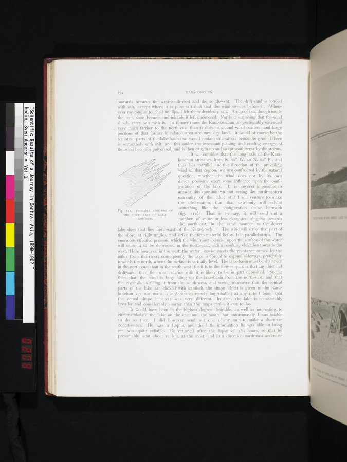 |
| カラ・コシュンの北東部のまず確実な輪郭。PROBABLE CONTURE OF THE NORTH-EAST OF KARA-KOSCHUN. |
I 72 KARA-KOSCI IUN.
onwards towards the west-south-west and the south-west. The drift-sand is loaded with salt, except where it is pure salt dust that the wind sweeps before it. Whenever my tongue touched my lips, I felt them decidedly salt. A cup of tea, though inside the tent, soon became undrinkable if left uncovered. Nor is it surprising that the wind should carry salt with it. In former times the Kara-koschun unquestionably extended very much farther to the north-east than it does now, and was broader; and large portions of that former inundated area are now dry land. It would of course be the remotest parts of the lake-basin that would contain salt water; hence the ground there is »saturated» with salt, and this under the incessant planing and eroding energy of the wind becomes pulverised, and is then caught up and swept south-west by the storms. If we consider that the long axis of the Karakoschun stretches from S. 6o° W. to N. 6o° E., and
thus lies parallel to the direction of the prevailing
wind in that region, we are confronted by the naturalquestion, whether the wind does not by its own
direct pressure exert some influence upon the confi- guration of the lake. It is however impossible to answer this question without seeing the north-eastern
extremity of the lake; still I will venture to make
the observation, that that extremity will exhibit
something like the configuration shown herewith
Fig. I I 2. PROBAPLE CONTURE OF
THE NORTH-EAST OF KARA- (fig. II2). That is to say, it will send out a
KOSCHUN. number of more or less elongated »fingers» towards
the north-east, in • the same manner as the desert lake does that lies north-east of the Kara-koschun. The wind will strike that part of the shore at right angles, and drive the firm material before it in parallel strips. The enormous effective pressure which the wind must exercise upon the surface of the water will cause it to be depressed in the north-east, with a resulting elevation towards the west. Here however, in the west, the water likewise meets the resistance caused by the influx from the river; consequently the lake is forced to expand sideways, preferably towards the north, where the surface is virtually level. The lake-basin must be shallower in the north-east than in the south-west, for it is in the former quarter that any dust and drift-sand that the wind carries with it is likely to be in part deposited. Seeing then that the wind is busy filling up the lake-basin from the north-east, and that the river-silt is filling it from the south-west, and seeing moreover that the central parts of the lake are choked with kamisch, the shape which is given to the Karakoschun on our maps is a j5riori extremely improbable; at any rate I found that the actual shape in 1901 was very different. In fact, the lake is considerably broader and considerably shorter than the maps make it out to be.
It would have been in the highest degree desirable, as well as interesting, to circumambulate the lake on the east and the south, but unfortunately I was unable to do so then. I did however send out one of my men to make a short reconnaissance. He was a Loplik, and the little information he was able to bring me was quite reliable. He returned after the lapse of 51/2 hours, so that he presumably went about I i km. at the most, and in a direction north-east and east-
.
|
Copyright (C) 2003-2019
National Institute of Informatics(国立情報学研究所)
and
The Toyo Bunko(東洋文庫). All Rights Reserved.
本ウェブサイトに掲載するデジタル文化資源の無断転載は固くお断りいたします。