国立情報学研究所 - ディジタル・シルクロード・プロジェクト
| |||||||||
|
| Scientific Results of a Journey in Central Asia, 1899-1902 : vol.2 | |
| 1899-1902年の中央アジア旅行における科学的成果 : vol.2 |
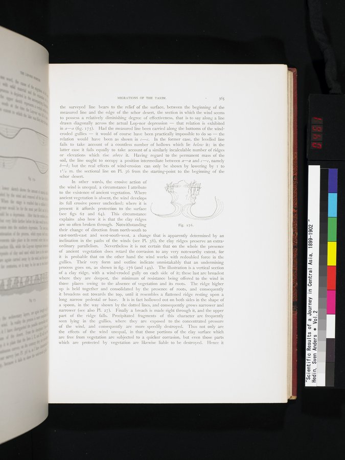 |
| ヤルダンの断面図。Vertical section of a jardang |
MIGRATIONS OF THE TARIM. 365
the surveyed line bears to the relief of the surface, between the beginning of the measured line and the edge of the schor desert, the section in which the wind seems to possess a relatively diminishing degree of effectiveness, that is to say along a line drawn diagonally across the actual Lop-nor depression — that relation is exhibited in a—a (fig. 175). Had the measured line been carried along the bottoms of the wind-eroded gullies — it would of course have been practically impossible to do so — the relation would have been as shown in c—c. In the former case, the levelled line fails to take account of a countless number of hollows which lie below it; in the latter case it fails equally to take account of a similarly incalculable number of ridges or elevations which rise above it. Having regard to the permanent mass of the soil, the line ought to occupy . a position intermediate between a—a and c—c, namely b—b; but the real effects of wind-erosion can only be shown by lowering by I to II/2 m. the sectional line on Pl. 36 from the starting-point to the beginning of the
are so often broken through. Notwithstanding Fig. 17 6.
schor desert.
In other words, the erosive action of
SI
the wind is unequal, a circumstance I attribute
to the existence of ancient vegetation. Where ancient vegetation is absent, the wind develops its full erosive power unchecked; where it is present it affords protection to the surface (see figs 62 and 64). This circumstance
explains also how it is that the clay ridges
P Y --
their change of direction from north-south to
east-north-east and west-south-west, a change that is apparently determined by an inclination in the paths of the winds (see Pl. 38), the clay ridges preserve an extraordinary parallelism. Nevertheless it is not certain that on the whole the presence of ancient vegetation does retard the corrasion to any very noteworthy extent, for it is probable that on the other hand the wind works with redoubled force in the gullies. Their very form and outline indicate unmistakably that an undermining process goes on, as shown in fig. 176 (and 149). The illustration is a vertical section of a clay ridge, with a wind-eroded gully on each side of it; these last are broadest where they are deepest, the minimum of resistance being offered to the wind in those places owing to the absence of vegetation and its roots. The ridge higher up is held together and consolidated by the presence of roots, and consequently it broadens out towards the top, until it resembles a flattened ridge resting upon a long narrow pedestal or base. It is in fact hollowed out on both sides in the shape of a spoon, in the way shown by the dotted lines, and consequently grows narrower and narrower (see also Pl. 27). Finally a breach is made right through it, and the upper part of the ridge falls. Precipitated fragments of this character are frequently seen lying in the gullies, where they are exposed to the concentrated pressure of the wind, and consequently are more speedily destroyed. Thus not only are the effects of the wind unequal, in that those portions of the clay surface which are free from vegetation are subjected to a quicker corrasion, but even those parts which are protected by vegetation are likewise liable to be destroyed. Hence it
|
Copyright (C) 2003-2019
National Institute of Informatics(国立情報学研究所)
and
The Toyo Bunko(東洋文庫). All Rights Reserved.
本ウェブサイトに掲載するデジタル文化資源の無断転載は固くお断りいたします。