国立情報学研究所 - ディジタル・シルクロード・プロジェクト
| |||||||||
|
| Scientific Results of a Journey in Central Asia, 1899-1902 : vol.2 | |
| 1899-1902年の中央アジア旅行における科学的成果 : vol.2 |
 |
| クム・チャプガンのタリム川、4月10日。Tarim at kum-tschapghan, April 10. | |
| クム・チャプガンとトスン・チャプガン、1900年。THE KUM-TSCHAPGHAN AND TUSUN-TSCHAPGHAN ANNO 1900. |
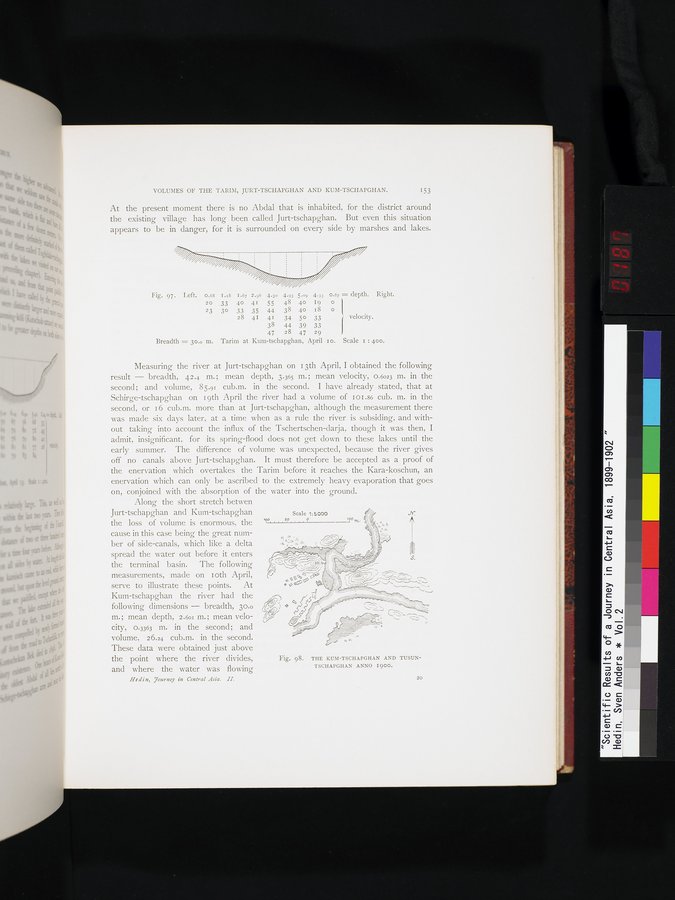
VOLUMES OF THE TARIM, JURT-TSCHAPGHAN AND KUM-TSCHAPGHAN. 153
At the present moment there is no Abdal that is inhabited, for the district around the existing village has long been called Jurt-tschapghan. But even this situation appears to be in danger, for it is surrounded on every side by marshes and lakes.
Fig. 97. Left. 0.68 I.i8 1.67 2.96 4.3o 4.93 5.09 4.33 0.87 = depth. Right.
20 33 40 41 55 48 40 19 0
23 30 33 35 44 38 40 18 o
28 41 41 34 50 33 J velocity.
38 44 39 33
47 28 47 29
Breadth = 30.o m. Tarim at Kum-tschapghan, April io. Scale 1 : 400.
Measuring the river at Jurt-tschapghan on 13th April, I obtained the following result — breadth, 42.4 m. ; mean depth, 3.365 m. ; mean velocity, 0.6023 m. in the second; and volume, 85.91 cub.m. in the second. I have already stated, that at Schirge-tschapghan on 19th April the river had a volume of 101 .86 cub. m. in the second, or 16 cub.m. more than at Jurt-tschapghan, although the measurement there was made six days later, at a time when as a rule the river is subsiding, and without taking into account the influx of the Tschertschen-darja, though it was then, I admit, insignificant, for its spring-flood does not get down to these lakes until the early summer. The difference of volume was unexpected, because the river gives off no canals above Jurt-tschapghan. It must therefore be accepted as a proof of the enervation which overtakes the Tarim before it reaches the Kara-koschun, an enervation which can only be ascribed to the extremely heavy evaporation that goes on, conjoined with the absorption of the water into the ground.
Along the short stretch betwen
Jurt-tschapghan and Kum-tschapghan Scale 1:5000 / .n''
the loss of volume is enormous, the 'q° S° - 29
°m- *1..i
Kum-tschapghan the river had the following dimensions — breadth, 30.0 m.; mean depth, 2.601 m.; mean velocity, 0.3363 m. in the second; and
volume, 26.24 cub.m. in the second.
These data were obtained just above the point where the river divides, and where the water was flowing
He d i n, ,journey in Central Asia. IL.
Cti1-■.^_
\- ✓ J
Fig. 98. THE KUM-TSCHAPGHAN AND TUSUNTSCHAPGHAN ANNO 1900.
ber of side-canals, which like a delta
cause in this case being the great num-
spread the water out before it enters A
measurements, made on oth April,
8.
the terminal basin. The following
serve to illustrate these points. At ,e1:* - - "? - •
20
|
Copyright (C) 2003-2019
National Institute of Informatics(国立情報学研究所)
and
The Toyo Bunko(東洋文庫). All Rights Reserved.
本ウェブサイトに掲載するデジタル文化資源の無断転載は固くお断りいたします。