National Institute of Informatics - Digital Silk Road Project
| |||||||||
|
| Scientific Results of a Journey in Central Asia, 1899-1902 : vol.1 |
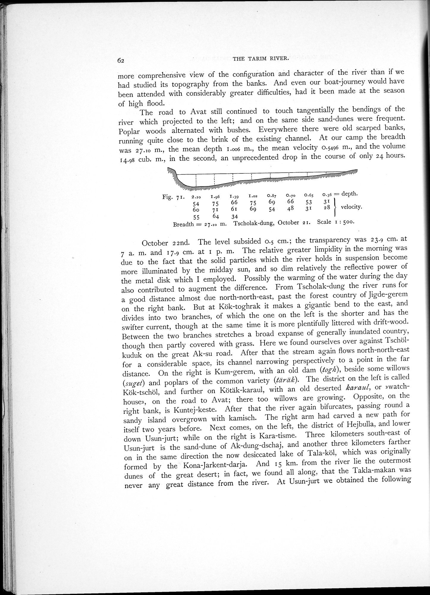 |
| Tscholak-dung, October 21. |
62 THE TARIM RIVER.
more comprehensive view of the configuration and character of the river than if we had studied its topography from the banks. And even our boat journey would have been attended with considerably greater difficulties, had it been made at the season of high flood.
The road to Avat still continued to touch tangentially the bendings of the river which projected to the left; and on the same side sand-dunes were frequent. Poplar woods alternated with bushes. Everywhere there were old scarped banks, running quite close to the brink of the existing channel. At our camp the breadth was 27.Io m., the mean depth I.006 m., the mean velocity 0.5496 m., and the volume 14.98 cub. m., in the second, an unprecedented drop in the course of only 24 hours.
Fig. 7 I. 2.ro I.96 I.39 1.02 0.87 0.70 0.65 0.36 = depth.
54 75 66 75 69 66 53 31
6o 71 61 69 54 48 31 28 velocity.
55 64 34
Breadth = 27.ro m. Tscholak-dung, October 21. Scale I : 500.
October 22nd. The level subsided 0.5 cm.; the transparency was 23.9 cm. at 7 a. m. and 17.9 cm. at I p. m. The relative greater limpidity in the morning was due to the fact that the solid particles which the river holds in suspension become more illuminated by the midday sun, and so dim relatively the reflective power of the metal disk which I employed. Possibly the warming of the water during the day also contributed to augment the difference. From Tscholak-dung the river runs for a good distance almost due north-north-east, past the forest country of Jigde-gerem on the right bank. But at Kök-toghrak it makes a gigantic bend to the east, and divides into two branches, of which the one on the left is the shorter and has the swifter current, though at the same time it is more plentifully littered with drift-wood. Between the two branches stretches a broad expanse of generally inundated country, though then partly covered with grass. Here we found ourselves over against Tschölkuduk on the great Ak-su road. After that the stream again flows north-north-east for a considerable space, its channel narrowing perspectively to a point in the far distance. On the right is Kum-gerem, with an old dam (loth), beside some willows (suget) and poplars of the common variety (täräk). The district on the left is called Kök-tschöl, and further on Kötäk-karaul, with an old deserted karaul, or »watch-house», on the road to Avat; there too willows are growing. Opposite, on the right bank, is Kuntej-keste. After that the river again bifurcates, passing round a sandy island overgrown with kamisch. The right arm had carved a new path for itself two years before. Next comes, on the left, the district of Hejbulla, and lower down Usun-jurt; while on the right is Kara-tisme. Three kilometers south-east of Usun-jurt is the sand-dune of Ak-dung-dschaj, and another three kilometers farther on in the same direction the now desiccated lake of Tala-köl, which was originally formed by the Kona-Jarkent-darja. And 15 km. from the river lie the outermost dunes of the great desert; in fact, we found all along, that the Takla-makan was never any great distance from the river. At Usun-jurt we obtained the following
|
Copyright (C) 2003-2019 National Institute of Informatics and The Toyo Bunko. All Rights Reserved.