National Institute of Informatics - Digital Silk Road Project
| |||||||||
|
| Scientific Results of a Journey in Central Asia, 1899-1902 : vol.1 |
 |
| The Jätim-tarim at Tägirmän; April 27. |
486 THE TARIM DELTA.
pass through the Tosghak-tschantschdi, so that it is intimately interlaced with the waterway we had recently navigated.
After that there appears continuous firm ground, sand dotted over with single poplars on the right, i. e. the left bank. At Scharkurun, on the same side of the river, are three huts, deserted four years ago. Here too the river is joined by several small arms, which drain out of lakes that are either parts of the Tschivilik-köl, or off shoots from it, and which, when the river drops, form small cataracts or waterfalls (scharkur7rn). At that time, when the spring floods were at their height, the velocity was 0.958 m. in the second, so that it was tempting for our canoe-men. Then, turning south-west, and threading a series of tschapghans and small lakes, with numerous poplars showing on both sides above the reeds, we approached the village of Tägirmän, which is known to us from our February excursion. It is there that the lowest emissary of the Tschivilik-köl discharges into the Jätim-tarim; and there too, on one of the arms, stands the mill from which the village derives its name; it was then hard at work. Here we disembarked, and made our Camp No. XXXVIII.
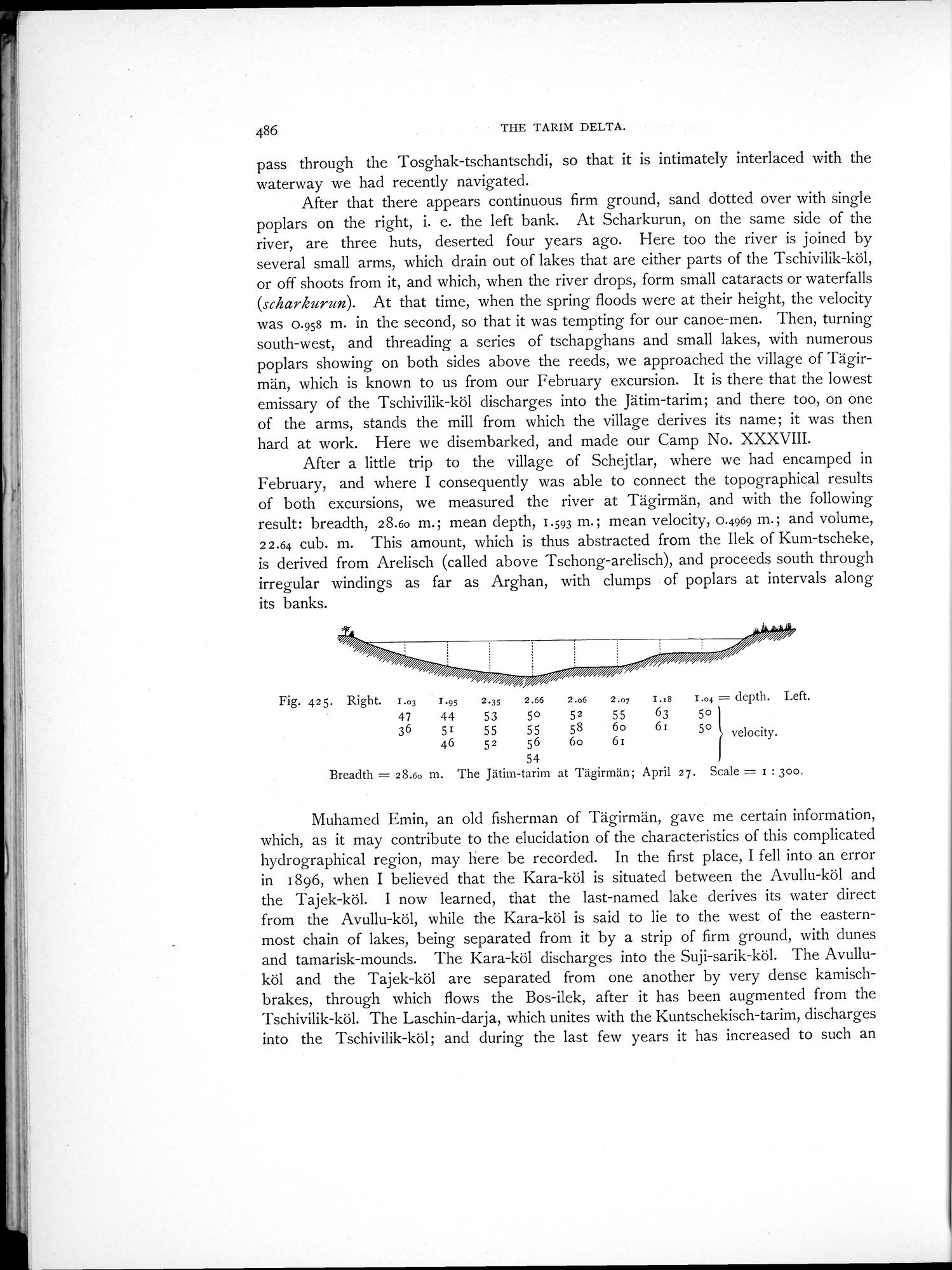
After a little trip to the village of Schejtlar, where we had encamped in February, and where I consequently was able to connect the topographical results of both excursions, we measured the river at Tägirmän, and with the following result: breadth, 28.6o m.; mean depth, 1.593 ni.; mean velocity, 0.4969 m.; and volume, 22.64 cub. m. This amount, which is thus abstracted from the Ilek of Kum-tscheke, is derived from Arelisch (called above Tschong-arelisch), and proceeds south through irregular windings as far as Arghan, with clumps of poplars at intervals along its banks.
Fig. 425. Right. 1.03
47
36
7.95 2.35 2.66 2.o6 2.07 I.18 1.04 = depth. Left.
44 53 50 52 55 63 5o
51 55 55 58 6o 61 5° velocity.
46 52 56 6o 6r
54
Breadth = 28.6o m. The Jätim-tarim at Tägirman; April 27. Scale = I : 300.
Muhamed Emin, an old fisherman of Tägirmän, gave me certain information, which, as it may contribute to the elucidation of the characteristics of this complicated hydrographical region, may here be recorded. In the first place, I fell into an error in 1896, when I believed that the Kara-köl is situated between the Avullu-köl and the "hajek-köl. I now learned, that the last-named lake derives its water direct from the Avullu-köl, while the Kara-köl is said to lie to the west of the easternmost chain of lakes, being separated from it by a strip of firm ground, with chines and tamarisk-mounds. The Kara-köl discharges into the Suji-sarik-köl. The Avulluköl and the Tajek-köl are separated from one another by very dense kamischbrakes, through which flows the Bos-ilek, after it has been augmented from the Tschivilik-köl. The Laschin-darja, which unites with the Kuntschekisch-tarim, discharges into the Tschivilik-köl; and during the last few years it has increased to such an
|
Copyright (C) 2003-2019 National Institute of Informatics and The Toyo Bunko. All Rights Reserved.