National Institute of Informatics - Digital Silk Road Project
| |||||||||
|
| Scientific Results of a Journey in Central Asia, 1899-1902 : vol.1 |
 |
| Jätim-tarim, June 3. | |
| Tarim at Arghan, June 4. |
THE INTRICATE NETWORK BETWEEN KEPEK-UJ AND AJAGH-ARGHAN. 193
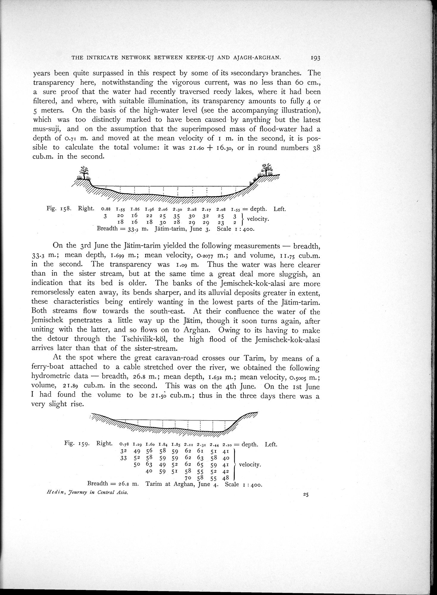
years been quite surpassed in this respect by some of its »secondary» branches. The transparency here, notwithstanding the vigorous current, was no less than 6o cm., a sure proof that the water had recently traversed reedy lakes, where it had been filtered, and where, with suitable illumination, its transparency amounts to fully 4 or 5 meters. On the basis of the high-water level (see the accompanying illustration), which was too distinctly marked to have been caused by anything but the latest mus-suji, and on the assumption that the superimposed mass of flood-water had a depth of 0.71 m. and moved at the mean velocity of 1 m. in the second, it is possible to calculate the total volume: it was 2I.6o + 16.3o, or in round numbers 38 cub.m. in the second.
Fig. 158. Right. 0.88 I.ss I.86 I.96 2.o6 2.3o 2.28 2.17 2.o8 1.55 = depth. Left.
3 20 16 22 25 35 3o 32 25 3 } velocity.
18 r6 IS 30 28 29 29 23 2
Breadth = 33.3 m. Jätim-tarim, June 3. Scale r : 400.
On the 3rd June the Jätim-tarim yielded the following measurements - breadth, 33.3 m.; mean depth, 1.699 m.; mean velocity, 0.2077 m.; and volume, 11.75 cub.m. in the second. The transparency was 1.09 m. Thus the water was here clearer than in the sister stream, but at the same time a great deal more sluggish, an indication that its bed is older. The banks of the Jemischek-kok-alasi are more remorselessly eaten away, its bends sharper, and its alluvial deposits greater in extent, these characteristics being entirely wanting in the lowest parts of the Jätim-tarim. Both streams flow towards the south-east. At their confluence the water of the Jemischek penetrates a little way up the Jätim, though it soon turns again, after uniting with the latter, and so flows on to Arghan. Owing to its having to make the detour through the Tschivilik-köl, the high flood of the Jemischek-kok-alasi arrives later than that of the sister-stream.
At the spot where the great caravan-road crosses our Tarim, by means of a ferry-boat attached to a cable stretched over the river, we obtained the following hydrometric data - breadth, 26.8 m. ; mean depth, 1.632 m.; mean velocity, 0.5005 m. ; volume, 21.89 cub.m. in the second. This was on the 4th June. On the 1st June
I had found the volume to be 21.50 cub.m.; thus in the three days there was a very slight rise.
Fig. 159. Right. 0.78 1.29 I.6o 1.84 I.85 2.xx 2.31 2.44 2.xo = depth. Left.
32 49 56 58 59 62 61 51 41 1
33 52 58 59 59 62 63 58 4o Il
5o 63 49 52 62 65 59 41 r velocity.
40 59 51 58 55 52 42 I
7o 58 55 48 1
Breadth = 26.8 m. Tarim at Arghan, June 4. Scale 1 : 400.
Hedin, Journey in Central Asia.
25
|
Copyright (C) 2003-2019 National Institute of Informatics and The Toyo Bunko. All Rights Reserved.