National Institute of Informatics - Digital Silk Road Project
| |||||||||
|
| Scientific Results of a Journey in Central Asia, 1899-1902 : vol.1 |
 |
350 THE TSCHERTSCHEN DESERT.
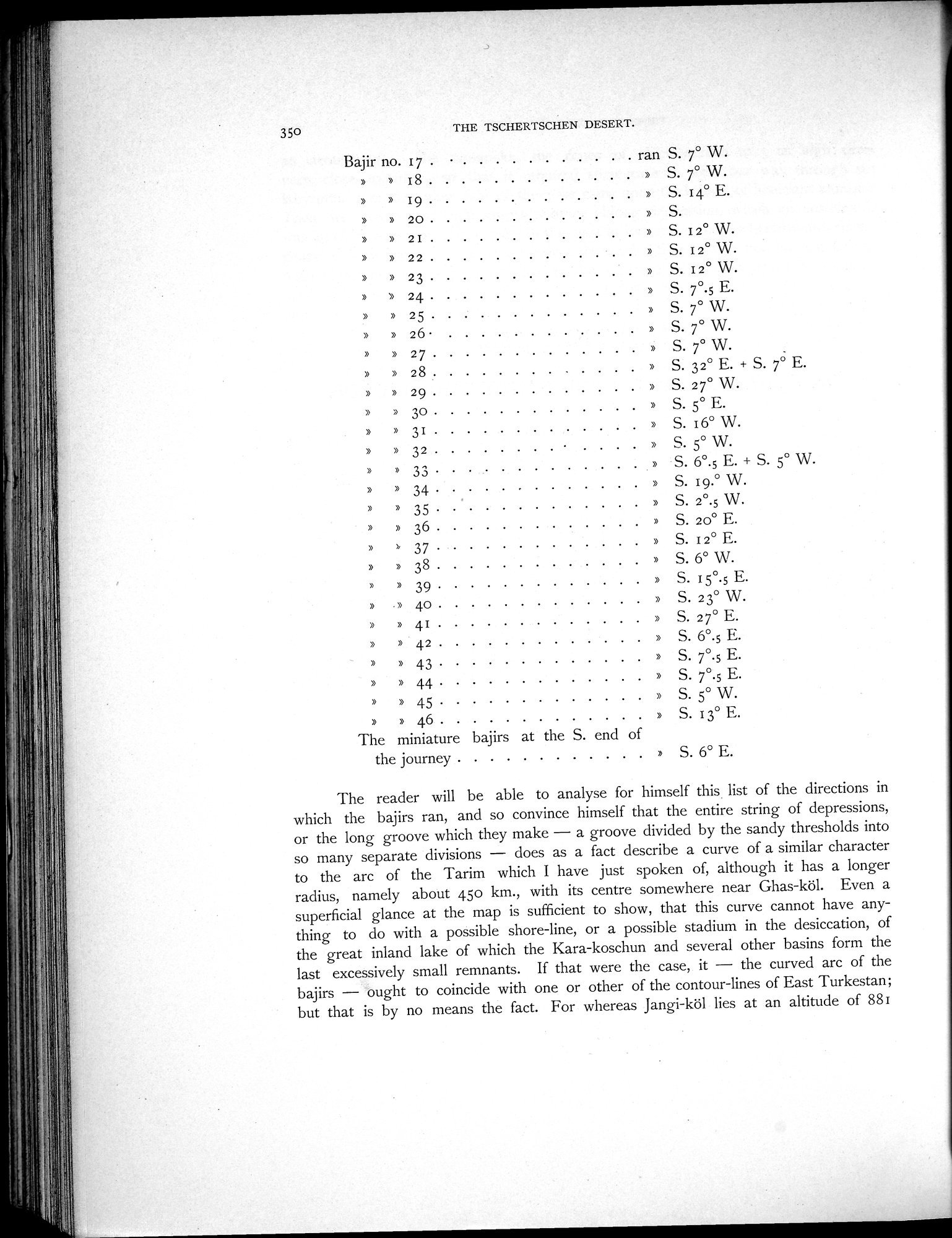
Bajir no. 17 . • ran S. 7° W.
» 18 » S. 7° W.
» 19 » S. 14° E.
» » 20 » S.
» 21 » S. 12° W.
» » 22 » S. 12° W.
» » 23 » S. I2° W.
» 24 » S. 7°.5 E.
» » 25 » S. 7° W.
» 26 • » S. 7° W.
» 27 » S. 7° W.
» 28 » S. 32° E. + S. 7° E.
» » 29 » S. 27° W.
» » 30 » S. 5° E.
» 31 » S. 16° W.
» 32 » S. 5° W.
» 33 » S. 6°.5 E. + S. 5° W.
» » 34 » S. 19.° W.
» 35 » S. 2°.5 W.
» 36 » S. 20° E.
' 37 » S. 12° E.
» 38 » S. 6° W.
» 39 » S. 15°.5 E.
.» 40 » S. 23° W.
» 41 » S.27°E.
» 42 » S. 6°.5 E.
» 43 » S. 7°.5 E.
» 44 » S. 7°.5 E.
» 45 » S. 5° W.
» 46 » S. 13° E.
The miniature bajirs at the S. end of
the journey » S. 6° E.
The reader will be able to analyse for himself this list of the directions in which the bajirs ran, and so convince himself that the entire string of depressions, or the long groove which they make — a groove divided by the sandy thresholds into so many separate divisions — does as a fact describe a curve of a similar character to the arc of the Tarim which I have just spoken of, although it has a longer radius, namely about 45o km., with its centre somewhere near Ghas-köl. Even a superficial glance at the map is sufficient to show, that this curve cannot have anything to do with a possible shore-line, or a possible stadium in the desiccation, of the great inland lake of which the Kara-koschun and several other basins form the last excessively small remnants. If that were the case, it — the curved arc of the bajirs — ought to coincide with one or other of the contour-lines of East Turkestan; but that is by no means the fact. For whereas Jangi-köl lies at an altitude of 881
|
Copyright (C) 2003-2019 National Institute of Informatics and The Toyo Bunko. All Rights Reserved.