National Institute of Informatics - Digital Silk Road Project
| |||||||||
|
| Scientific Results of a Journey in Central Asia, 1899-1902 : vol.1 |
 |
| Sadik-bajning-arighi, Nov. 23. |
I24. THE TARIM RIVER.
dry, called Kamber Schang janing jokarki jangi-arighi, made for the purpose of irrigating some now deserted fields. The bottom of this canal was a good meter higher than the surface of the river. The Tarim is next joined from the left by an arm, which at the season of high flood, but then only, pours into it a portion of the water of the Kara-akin. On the same side of the Tarim lies an unnamed lake, with a connecting arm, through which there runs a current, sometimes inwards, sometimes outwards, according as the levels of river and lake vary with regard to one another. Here stand two or three deserted satmas. At Mus-asti, or rather Munghus-asti, or the Hung-up Antelope's Skull, on the left bank, an atschal, or »high-water branch•, leaves the river, but rejoins it again a good bit lower down. Its upper end is narrow, though its lower end expands. At each extremity there is a sheet of water; otherwise it is dry, though in the high-water season it is said to swell to a very considerable stream. The high sand again touches the river at Sejt-uji, a hut abandoned some ten years ago by its former inhabitants, shepherds or hunters. The locality is what is known as kona kofti (= gobi) jer, i. e. »an old desert region»; in other words, it is waterless. Sadik-bajning-arighi is the name given to a canal which until three years ago, when it went out of use, was employed to irrigate some wheat-fields. Another canal, Muhamed Mirab-arighi, was likewise dry. All these canals issue from the right bank, a circumstance connected no doubt with the river's tendency to shift to the right, for the likelihood of their getting filled is then the stronger; possibly also the ground on that side lies lower. The watercourses which quit the river spontaneously on that side are in the lower-lying localities separated from it for considerable distances. On the left the Tarim is joined by an arm of the Kona-darja (Tunne-kis), while a second enters it at Arelisch, its termination being choked with silt. The name of Jar-jeghan-kum, which occurs here, is significant: it means, the Sand of the Eaten away Bank; and in point of fact, the river does just there encroach again upon the sand-dunes. To the north there is reported to be a considerable belt of sand. Places in which the dunes are eaten away by the river become quite common lower down, as we shall see subsequently. In the great majority of cases these places are situated on the right bank.
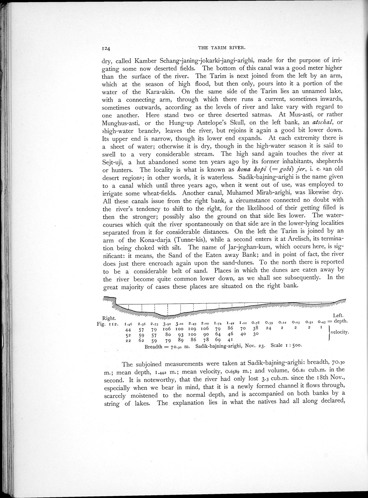
Right. Left.
Fig. II 2. I.46 2.36 2.73 3.90 3.ox 2.49 2.oz I.74 I.42 I.xx 0.78 0.39 O.12 0.03 O.51 0.45 = depth.
44 57 79 io6 too 109 106 79 86 7o 38 24 2 2 2 1
52 59 57 8o 93 too 90 64 46 4o 3o velocity.
22 62 59 79 89 86 78 69 41
Breadth = 70.3o m. Sadik-bajning-arighi, Nov. 23. Scale I : 5oo.
The subjoined measurements were taken at Sadik-bajning-arighi: breadth, 70.30 m.; mean depth, 1.442 m.; mean velocity, 0.6589 m.; and volume, 66.8i cub.m. in the second. It is noteworthy, that the river had only lost 3.3 cub.m. since the 18th Nov., especially when we bear in mind, that it is a newly formed channel it flows through, scarcely moistened to the normal depth, and is accompanied on both banks by a string of lakes. The explanation lies in what the natives had all along declared,
|
Copyright (C) 2003-2019 National Institute of Informatics and The Toyo Bunko. All Rights Reserved.