National Institute of Informatics - Digital Silk Road Project
| |||||||||
|
| Scientific Results of a Journey in Central Asia, 1899-1902 : vol.1 |
 |
| Koral dung, November 18. |
II2 THE TARIM RIVER.
vestige to be seen, and of the great river only the extremities of its nearest windings. The remainder of the inundated country was hidden by the all-pervading reeds. It is no easy task to map a country such as that. You can only feel quite sure about the river itself and the tracts immediately contiguous to it. The more distant features, as . well as those that are 'masked by the conformation of the ground, can only be entered from description, and consequently can only be dealt with in outline. Now, as we. have seen, there extends in this region on both banks of the Tarim a broad network of intricate, anastomosing watercourses, channels, branches, marshes, swamps and . lakes. • These .last were, at the season of our visit, almost without exception cuit off from the river, though as a rule still pretty full of water, surviving from the copious overflows . of the summer. • The channels, however, which connect them with the ' river and through which their supplies of water are contributed, were at that period dry, and their beds lay for the most part one meter or more above the existing level of the Tarim; so that these marginal lagoons levy no contribution Ligon the river at the autumn season. This circumstance, taken in conjunction with the actual rise of the river at that period, explains the almost constant volume of the Tarim, • or rather accounts for its slow subsidence. Were it not for these circumstances, the river would fall at a much more rapid rate in consequence of evaporation, absorption into the ground, and the drain of this or the other still flowing channel, such as the Lämpa-akin.
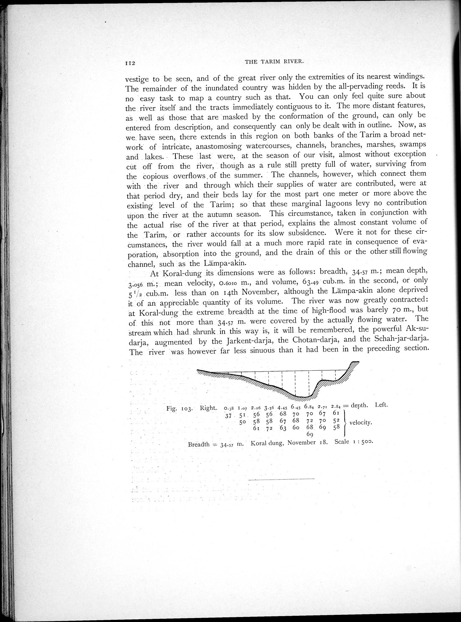
: At Koral-dung its dimensions were as follows: breadth, 34.57 m.; mean depth,
3.o56 nn.; . mean velocity, 0.6010 m., and volume, 63.49. cub.m. in the second, or only 5 1/2 : cub.m. less than on 14th November, although the Lämpa-akin alone deprived it of an. appreciable guiantity of its volume. The river was now greatly contracted: at Koral-dung the extreme breadth at the time of high-flood was barely 7o m., but of this not more than 34.57 m. were covered by the actually flowing water. The stream which had. shrunk . in this way is, it will be remembered, the powerful Ak-sudarja, augmented by the Jarkent-darja, the Chotan-darja, and the Schah-jar-darja. The river 'was however far less sinuous than it had been in the preceding section.
Fig: 103. Right.. 0.38 I.07 2.26 3.56 4.49 6.45 6.84 2.7x 2.84 = depth. Left.
.3.7. 51. 56 56 68 7o 7o 67 61
5o 58 58 67 68 72 7o 52 velocity.
61 72 "63 6o 68. 69 58
69
Breadth - 34.57 m. Koral clung, November 18. Scale 1 : 500.
|
Copyright (C) 2003-2019 National Institute of Informatics and The Toyo Bunko. All Rights Reserved.