National Institute of Informatics - Digital Silk Road Project
| |||||||||
|
| Eine Routenaufnahme durch Ostpersien : vol.2 |
 |
»
»
»
»
»
i)
»
»
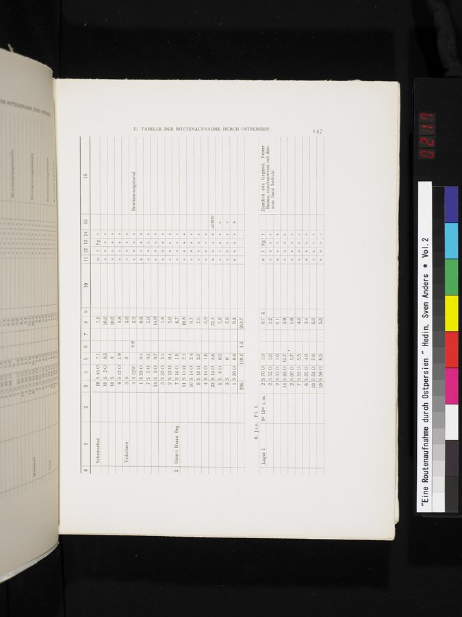
Lager I
9h 15m a. m.
2 2 2 14 2 7 6
S 12W
S 25 0 0.4
S 2 0 0.2
S 3 0 0.7 S 52 0 2.4 S 12 0 0.4 S 16 0 1.9 S 11 0 2.1 S 14 0 2.4
S 18 0 2.5 7.6
S 14 0 1.0 3.9
S 14 0 5.6 22.3
S 6 0 0.5 5.0
S 0 3.0
S 70 0 1.9
5.5
4.9
6. Jan. P1. 1.
S 52 0 S 55 0 S 65 0 S 60 0 5520 S 55 0
1.6 1.6 12.7 1.7
0.7 1.2 1.1 5.9 1.0 4.3 3.4
K
»
»
»
»
»
»
»
»
»
»
»
f
»
»
»
Fg
»
»
»
»
»
»
»
»
»
t
»
_uL NW
»
Ziemlich öde Gegend. Fester Boden, streckenweise mit dûnnem Sand bedeckt
Bewässerungskanal
I[. TABELLE DER ROUTENAUFNAHME DURCH OSTPERSIEN.
»
» )
»
» »
»
10
S 51 0
7.8
6.3
»
»
»
10
S 58 0
8.5
5.3
» »
|
Copyright (C) 2003-2019 National Institute of Informatics and The Toyo Bunko. All Rights Reserved.