National Institute of Informatics - Digital Silk Road Project
| |||||||||
|
| Eine Routenaufnahme durch Ostpersien : vol.2 |
 |
5.9
1.7
4.8
1.0
2.5
1.3
3.9
1.2
6.6
2.4
4
N 87W
2W
S 78W
3 S 35W
5 IS 75W
4 S 15W
S 20W
4 21W
10 S •
4 S 12W
3
S
1
2
2
5
1
3
1
~.4
2 S 45 0
S
0.0
2
0.8
1 S 50 0
1 5300 0.5
3 S 600 2.6
4 S 40 0 2.6
1.9 0.6
10.0 0.9
4.0 0.0
1.7
4.0 0.2
2.0 0.0
3.7
10.0
3.9
3.0
1.9
0.4
1.0
1.9
1.7 1.0
4.1 .8
0.2 1.0
3.0
1.0
1.4
2.0
0.6
0.9
1.5
3.1
100
7
6
S 0.0
S 15W1 0.5
S 60W1
2
N 72W
10
4
N 85W
W
S 56W
S 10W
0.5
S 10 0
S
-070
2
S 1501 0.5
0.9
11S65W
n
» n »
»
» » »
»
n
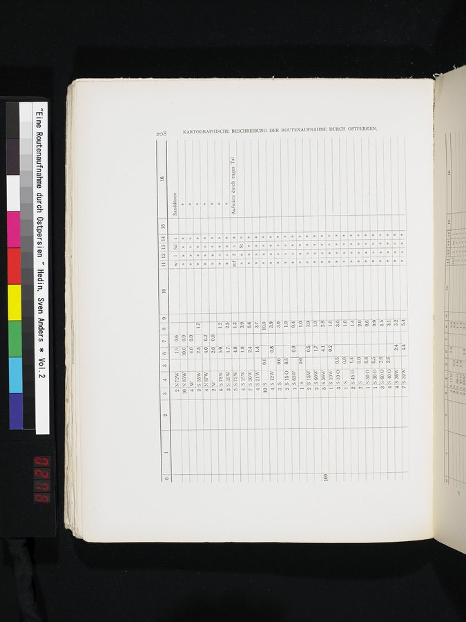
Aufwärts durch enges Tal
KARTOGRAPHISCHE BESCHREIBUNG DER ROUTENAUFNAHME DURCH OSTPERSIEN.
»
» » »
» »
» »
auf
f » »
St »
» » »
»
» n
» »
» » »
» »
» » »
» » »
»
» »
» »
» » »
n
» »
n »
» » »
» » »
» n »
n
» »
» » »
» »
1 Sd t
Sanddünen
1 2
4 5 6 7 8 9 10 11 12 13 14 15 16
0
N
0
00
S 55W 2.5
3
1.4
0.0
0.8
0.0
2.4
n
3.2
5.4
4 S 36W
» »
7 S3T-Wr 4.4
n »
|
Copyright (C) 2003-2019 National Institute of Informatics and The Toyo Bunko. All Rights Reserved.