National Institute of Informatics - Digital Silk Road Project
| |||||||||
|
| Eine Routenaufnahme durch Ostpersien : vol.2 |
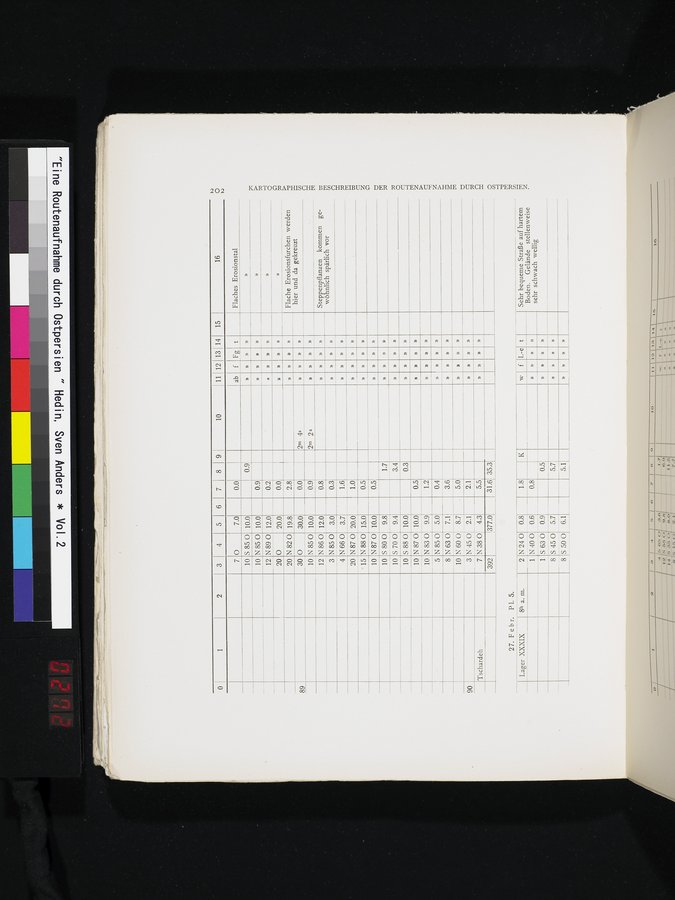 |
7 10 10 12 20 20
S 85 0
N 85 0
N 89 0
o
N 82 0
o
0
30
»
»
10 N 85 0 12 N860
3 N 85 0
4 N 66 0
20 N 87 0
°15 N 88 0 10 N87 0 10 S 80 0 10 S 70 0 10 S 88 0 10 N 87 0
N 83 0
N 85 0
N 63 0
10
3
7
ab f t
» » »
» »
» » »
» »
» »
» »
» »
» » »
» »
n » »
» »
» » »
Tschardeh
Flaches Erosionstal
N 60 0 8.7
N 45 0 2.1
N 38 0 4.3
392
377.0
31.6 35.3
Sehr bequeme Straße auf hartem Boden. Gelände stellenweise sehr schwach wellig
'N3ISII3dZSO
27. Febr. P1. 5.
89
90
9.8 9.4 10.0 10.0 9.9 5.0 7.1
0.5
1.2
0.4
3.6
5.0
2.1
5.5
10
5
8
»
»
»
»
»
» »
» » »
» » »
Flache Erosionsfurchen werden ►d
hier und da gekreuzt
rn
tx,
Steppenpflanzen kommen gewöhnlich spärlich vor
10
2
i i i i l
3liHdN3nVN3ZnO/1
N
11 12 13 14 15 16 0
.4 5 6
1.7
3.4
0.3
n
»
..j
o
0
0.9
4s
0.0
0.9 0.2 0.0 2.8 0.0 0.9 0.8 0.3 1.6 1.0 0.5 0.5
7.0 10.0 10.0 12.0 20.0 19.8
30.0
10.0
12.0
3.0 3.7 20.0 15.0 10.0
|
Copyright (C) 2003-2019 National Institute of Informatics and The Toyo Bunko. All Rights Reserved.