National Institute of Informatics - Digital Silk Road Project
| |||||||||
|
| Eine Routenaufnahme durch Ostpersien : vol.2 |
 |
5
1 2
4
10 11 12 13 14 15
16
»
»
»
»
»
»
»
»
»
))
»
»
•
»
»
»
S 600 1.7
S 3 0 0.3
S 72 0 3.8
S 40 0
1.3
2
S 60 0 1.7
S 13W
0.9
S 50
S 20 0
S 2W,
S 12W
0.21
1.0
0.2
1.0
2
6
4
2
4
2
3
5
5
S 25W 2.1
S 12W 0.4
S 100 0.3i
S 0
1.5
S 120
2.0
S 130
0
S
S 8W 1.4
S 3W1 0.4
S 150 9.6
S 17 0 2.6
S 150 2.6
15
20 S 15 0 5.2
66
lm 19s
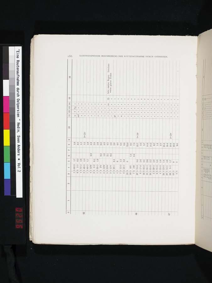
KARTOGRAPHISCHE BESCHREIBUNG DER ROUTENAUFNAHME DURC H OSTPERSIEN.
5
6
4
S 50 0
S 750
5.8
3.8
1.0
26
S 150
S 130
5.8
20
67
20 S 50
S 14 0 4.8
1.7
0
10
S
9
S
1m 21s
»
»
t
1.0
w
f Fg
6.0
auf
1.2
1.5
1m21s
»
1.0
»
3.9
»
2.0
2.8
»
5.0
4.9
Sehr starker Regen. Streckenweise glatter Boden
»
»
»
»
5
2
2
4
7
9
23
10
7
37
9
10
4.5
2.0
2.0
4.0
6.8
8.8'
23.0
9.9
7.0
35.7
8.6
9.7
14.8
19.3
3.2
1.6
3.9
25.3
19.4
»
ns
•
»
»
19.9
10.0
9.0
»
»
ab
»
»
|
Copyright (C) 2003-2019 National Institute of Informatics and The Toyo Bunko. All Rights Reserved.