National Institute of Informatics - Digital Silk Road Project
| |||||||||
|
| Eine Routenaufnahme durch Ostpersien : vol.2 |
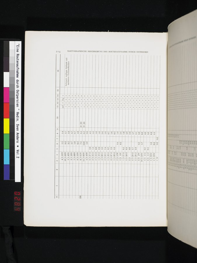 |
10 111 12 13 14
auf f Fg t
N
1 2 3 4 5 6 7 8 9
15
16
S 33W
4
2.2
3.4
10
S 68W
9.3
3.7
Schwach welliges Gelände mit mehreren Erosionsfurchen
»
KARTOGRAPHISCHE BESCHREIBUNG DER ROUTENAUFNAHME DURCH OSTPERSIEN
5 S 40W
3.2
3.8
»
»
D
5 S 20W
1.7
4.7
D
»
2 S 68W
1.9
0.7
w
»
»
»
8 S 53W
6.4
4.8
»
n
,)
106
8 S 65W
7.3
3.4
2m 20s
»
D
14 S 68W
13.0
5.2
2m 30s
n
»
»
4 S 46W
2.9
2.8
»
»
»
S 27 0
5
2.3
4.5
»
2 S 35 0 1.1
1.6
»
»
»
2 S 25 0 0.8
1.8
»
»
»
1 5 10 0 0.2
1.0
n
»
»
»
4 5 60 0 3.5
2.0
» »
S 53 0
S 48 0
S 57 0
3
2.4
0.7
2.5
1.8
»
»
1
0.7
»
»
»
»
3
1.6
»
»
m
»
1 S 600 0.9
0.5
»
»
»
2 S 13W
0.4
1.9
»
»
))
»
2 S 5W 0.2
2.0
»
»
D
»
1 S 17 0 0.3
5 5 10 0 0.9
2 S 0.0
5 5200 1.7
2.3
1.0
»
»
4.9
»
»
2.0
»
D
»
i
4.7
»
»
»
»
S 28 0 S 2W S 10W S 30
5
4.4
»
5
10
4
0.2
5.0
U
»
D
1.7
9.8
»
»
0.2
0.4
4.0
»
,)
n
»
5
S 50
5.0
»
»
»
»
1
S 75W
1.0
0.3
»
»
»
»
1
0.3
0.9
» » »
1 W
I.0
0.0
»
»
|
Copyright (C) 2003-2019 National Institute of Informatics and The Toyo Bunko. All Rights Reserved.