National Institute of Informatics - Digital Silk Road Project
| |||||||||
|
| Eine Routenaufnahme durch Ostpersien : vol.2 |
 |
» » »
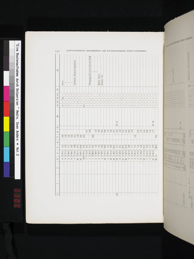
15
16
» » ))
» » »
::Kleine Kevir Kleines Tal » ©©
»
»
»
»
»
»
»
»
»
w
»
KARTOGRAPHISCHE BESCHREIBUNG DER ROUTENAUFNAHME DURCH OSTPERSIEN.
1.0 4.3 3.0 10.0 4.6
1.7
2.6
0.5
0.9
1.9
6 N 68 0 5.6
4 N740 3.8 10 N 81 O 9.9
16 N 60 0 13.9
0.5
S 45 0
0.5
1
N700
0.7
0.7
5250
N50 0
S 30 0
5590
S 80 0
S 85 0 S 68 0
10 S 81-0
0.4
0.8
9.9
0.9
0.6
1.6
S 80 0
5810
5700
S 83 0
S 65 0
5800
0
12.8
3.0
1.9
5.8
12.2
6.9
2.7
9.8
30.0
2.3
0.5
0.7
1.5
4.4
0.9
1.3
1.7
0.0
6s
2.2
1.1
1.6
8.0
0.2
1
1
2
5
3
10
5
2 S 600 8 N81 0
2 S 70 0
6 S 76 0
13
3
13
7
3
10
30
0.7
10
10
8
128
10.0 9.4 6.4 16.9
17
1.7
1.0
1.3
7.9
S 86 0 5700 S 53 0 S 83 0
3.4 2m 2s
4.8
2.1
N60 0
N770
N690
f Fg t Kevir
» » »
» » »
» » Spärliche Steppenvegetation
»
»
» Übergang über einen kleinen Fluß
1 2 3 4 51 6
7 8 I 9 10 11
12113 14
5.2
7.8
4.7
3.0
1.8
1.8
6
8
5
»
1)
»
auf
»
|
Copyright (C) 2003-2019 National Institute of Informatics and The Toyo Bunko. All Rights Reserved.