国立情報学研究所 - ディジタル・シルクロード・プロジェクト
| |||||||||
|
| Eine Routenaufnahme durch Ostpersien : vol.2 | |
| 東ペルシアにおける踏査の記録 : vol.2 |
 |
2 3 4 5 6 7 8 I 9 10 11 12 13 14 15
1
16
0
14 S 50 0 10.7
9.0 w f Fg t
S 65 0 0.9
1
0.4
»
»
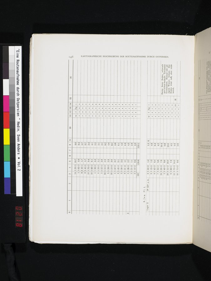
KARTOGRAPHISCHE BESCHREIBUNG DER ROUTENAUFNAHME DURCH OSTPERSIEN.
8
S 45 0 5.7
5.7
»
»
»
S 45 0 5.7
8
5.7
»
»
S 70 0 9.4
10
3.4
»
10
S 66 0 9.1
4.1
»
»
»
S 56 0 3.3
4
2.2
»
»
6
S 59 0 5.1
3.1
»
»
»
»
S 52 0 3.9
5
3.1
»
S 23 0 3.9
10
9.2
»
n
5
S 280 2.3
4.4
»
10
S 23 0 3.9
9.2
5
S 40 0 3.2
3.8
8
S 40 0 5.1
6.1
»
»
»
5
S 30 0 2.5
S 31 0 4.1
4.3
8
6.9
»
5
S 26 0 2.2
4.5
3
»
»
»
3
S 21 0 1.1
2.8
»
2
S 100 0.3
2.0
»
»
»
182
128.6
119.1
8. Jan. Pl. 1.
Lager II
9h 15m a. m.
2
S 40 0 1.3
1.5 K
f
Fg t
w
5 S 150 1.3
4.8
9
S 45 0
6.4
6.4
»
S 53 0
5.6
7
4.2
16 S 26 0
1 S 40 0
20 S 53 0
7.0
0.6
16.0
14.4
0.8
12.0
Harter fester Boden, schwach mit Schutt bedeckt. Trockenes Erosionsbett. Rinnsal mit salzigem Wasser. Schnee. Der Boden wird naß, aber nicht weich.
»
»
»
»
»
»
9 S 60 0
7.8
4.5
»
»
»
15 IS 73 0 14.3
10 S 730 9.6
4.4
» ns *
»
2.9
n
n
»
|
Copyright (C) 2003-2019
National Institute of Informatics(国立情報学研究所)
and
The Toyo Bunko(東洋文庫). All Rights Reserved.
本ウェブサイトに掲載するデジタル文化資源の無断転載は固くお断りいたします。