国立情報学研究所 - ディジタル・シルクロード・プロジェクト
| |||||||||
|
| Eine Routenaufnahme durch Ostpersien : vol.2 | |
| 東ペルシアにおける踏査の記録 : vol.2 |
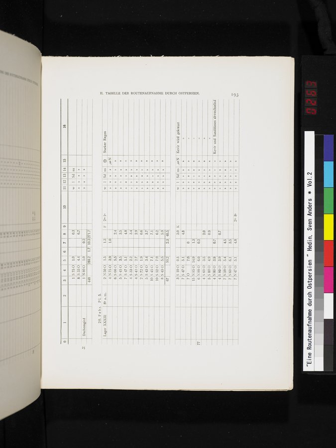 |
2 3 4 5 6 7 8 9 10 11 12 13
14 15
16
0
1 S 75 0 1.0
0.3
w i
Sd ns
S 33 0
4.4
6.7
8
» »
N H
1.0
N800
0.2
1
Dschemgird
»
288.2 1.7
10.3
448
271.7
20. Febr. P1. 5.
I
Sd ns
Lager XXXIII 8h a. m.
N500 1.5
1.3
2m is
Starker Regen
2
F
N75 0 3.9
yuN
1.0
4
S 66 0 5.5
6
2.4
S 45 0 3.5
3.5
5
»
S 47 0 5.1
7
4.8
»
»
S 33 0 2.2
4
3.4
»
4
S 43 0 2.7
2.9
»
»
2
S 72 0 1.9
0.6
5
S 43 0 3.4
3.7
»
»
S 450 7.1
10
7.1
»
10
S 52 0 7.9
6.2
n
»
S 43 0 5.5
8
5.9
n
»
i13ISliaasso 1-1021QQ
50.2
67
2.3
40.5
S 100
3
0.5
3.0
Sd
K
_wN
Kevir wird gekreuzt
w
ns
S 47 0
5.1
7
4.8
s
s
o
7
7.0
0
»
»
»
»
»
»
N85 0
15
14.9
1.3
»
N88 0
77
6.0
0.2
6
»
»
n
»
S 60 0
3.5
4
2.0
»
»
))
S 80 0
4.9
5
0.9
»
N80 0
3.9
0.7
4
Kevir und Sanddünen abwechselnd
»
S 80 0
3.9
4
0.7
»
n
»
N50 0
5.4
7
4.5
s
»
s
N 60 0 6.1 N 47 0 5.1
7
3.5
s
»
1.4
7
4.8
2m 8s
n
n
|
Copyright (C) 2003-2019
National Institute of Informatics(国立情報学研究所)
and
The Toyo Bunko(東洋文庫). All Rights Reserved.
本ウェブサイトに掲載するデジタル文化資源の無断転載は固くお断りいたします。