国立情報学研究所 - ディジタル・シルクロード・プロジェクト
| |||||||||
|
| Eine Routenaufnahme durch Ostpersien : vol.2 | |
| 東ペルシアにおける踏査の記録 : vol.2 |
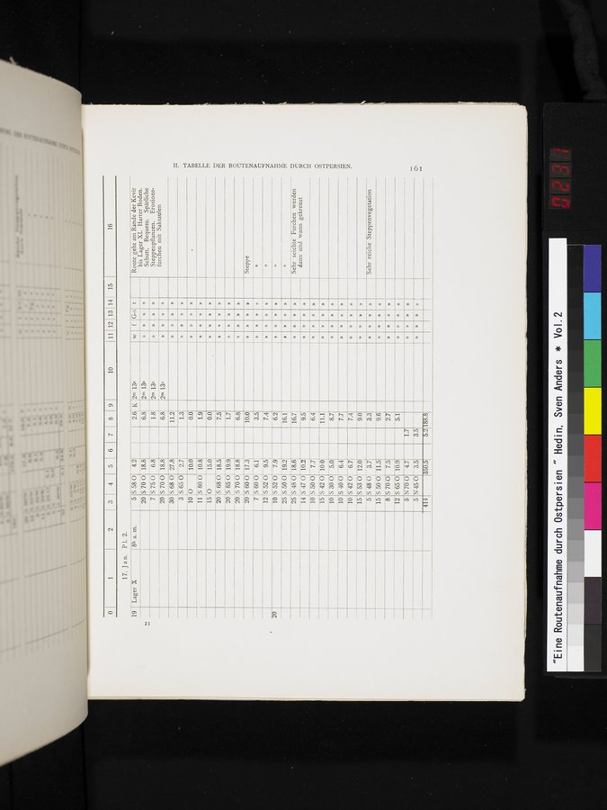 |
16
15
10 111112 13114
2 3 I 4
17. Jan. PI. 2.
8h a. m.
30
S 58 0
5700
5750
S 70 0
S 68 0
Route geht am Rande der Kevir bis Lager XI. Harter Boden. Schutt. Bequem. Spärliche Steppenpflanzen. Erosions-furchen mit SaksauIen
5
20
7
20
19 Lager X
w f G-s t
»
1.8 2m 13s » »
6.8 2m 13s
» »
»
»
» »
»
» »
»
» »
» »
»
» »
» »
» »
»
» »
» »
»
» »
» »
» »
»
» »
» »
2.6 K 2m 13s
6.8 2m 13s
11.2
1.3
0.0
1.9
0.0
7.5
1.7
6.8
10.0
3.5
7.4
6.2
3
S 65 0
0
10
11
S 80 0
O
15
20
S 68 0
4.2 18.8 6.8 18.8 27.8 2.7 10.0 10.8 15.0 18.5
S 85 0 19.9
S 70 0 18.8
S 60 0 17.3
5600 6.1
S 52 0 9.5
S 52 0 7.9
S 50 0 19.2 16.1
S 48 0 18.6 16.7
10 S 50 0 7.7 6.4
15 S 42 0 10 0 11.1
10 S 30 0 5.0 8.7
10 S 40 0 6.4 7.7
10 S 4 6.7 7.4
9.5
S 47 0 10.2
20 20 20 7 12 10 25 25
14
»
Steppe
»
»
Sehr seichte Furchen werden dann und wann gekreuzt
TABELLE DER ROUTENAUFNAHME DURCH OSTPERSIEN.
» »
»
»
»
15
9.0
5
»
3.3
S 53 0 12.0 S 48 0 3.7
Sehr reiche Steppenvegetation
15
8
12
5
5
414
S 50 0 11.5
5700 7.5
S 65 0 10.9
N700 4.7
N 45 0 3.5
350.5
9.6
2.7
5.1
1.7
3.5
5.2 188.8
» »
»
» » »
|
Copyright (C) 2003-2019
National Institute of Informatics(国立情報学研究所)
and
The Toyo Bunko(東洋文庫). All Rights Reserved.
本ウェブサイトに掲載するデジタル文化資源の無断転載は固くお断りいたします。