National Institute of Informatics - Digital Silk Road Project
| |||||||||
|
| Southern Tibet : vol.8 |
 |
FROM Ve-MO TO CHIEH-CHA.
I
~
J
|
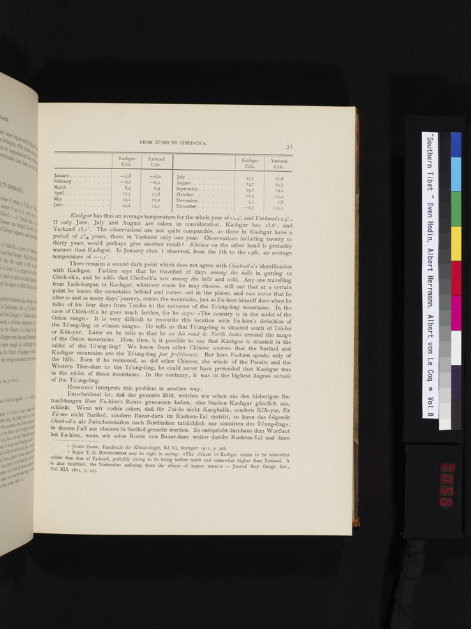
| Kashgar | Yarkand |
| Kashgar | Yarkand |
| January | -5,8 | -6,o | July | 27,5 | 27,6 |
| February | -0,I | -0,2 | August | 25,7 | 23,7 |
| March | 8,4 | 6,9 | September | 19,2 | 19,2 |
| April | 17,3 | 17,8 | October | 12,3 | 13,4 |
| May | 19,2 | 21,0 | November | 3,5 | 3,8 |
| June | 24,2 | 24,3 | December | -2,7 | -4,3 |
Kashgar has thus an average temperature for the whole year of i 2,4°, and Yarkand 12,3°.=
If only June, July and August are taken in consideration, Kashgar has 25,8°, and Yarkand 25,2°. The observations are not quite comparable, as those in Kashgar have a period of 31/2 years, those in Yarkand only one year. Observations including twenty to thirty years would perhaps give another result. Khotan on the other hand is probably warmer than Kashgar. In January 1896, I observed, from the 5th to the 14th, an average temperature of -1,2°.
There remains a second dark point which does not agree with Chieh-clia's identification
with Kashgar. Fa-hien says that he travelled 25 days among the hills in getting to Chieh-ch`a, and he adds that Chieh-ch`a Zeas among the hills and cold. Any one travelling from Tash-kurgan to Kashgar, whatever route he may choose, will say that at a certain point he leaves the mountains behind and comes out in the plains, and vice versa that he after so and so many days' journey, enters the mountains, just as Fa-hien himself does when he talks of his four days from Tzú-ho to the entrance of the Tsung-ling mountains. In the case of Chieh-ch` a he goes much farther, for he says : »The country is in the midst of the Onion range.» It is very difficult to reconcile this location with Fa-hien's definition of the Ts ung-ling or »Onion range». He tells us that Ts ung-ling is situated south of Tzü-ho or Kök-yar. Later on he tells us that he on his road to North India crossed the range of the Onion mountains. How, then, is it possible to say that Kashgar is situated in the midst of the Ts ung-ling ! We know from other Chinese sources that the Sarikol and Kashgar mountains are the Ts ung-ling par preference. But here Fa-hien speaks only of the hills. Even if he reckoned, as did other Chinese, the whole of the Pamirs and the Western Tien-shan to the Ts ung-ling, he could never have pretended that Kashgar was in the midst of these mountains. In the contrary, it was in the highest degree outside of the Ts' ung-ling.
HERRMANN interprets this problem in another way :
Entscheidend ist, daß das gesamte Bild, welches wir schon aus den bisherigen Betrachtungen über Fa-hien's Route gewonnen haben, eine Station Kashgar gänzlich aus.. schließt. Wenn wir vorhin sahen, daß für Tzú-ho nicht Karghalik, sondern Kök-yar, für Yii-mo nicht Sarikol, sondern Bazar-dara im Raskem-Tal eintritt, so kann das folgende Chieh-ch`a als Zwischenstation nach Nordindien tatsächlich nur »inmitten des Ts`ung-ling», in diesem Fall am ehesten in Sarikol gesucht werden. Es entspricht durchaus dem Wortlaut bei Fa-hien , wenn wir seine Route von Bazar-dara weiter durchs Raskem-Tal und dann
= JULIUS HANN, Handbuch der Klimatologie, Bd. III, Stuttgart 1911, p. 308.
2 Major T. G. MONTGOMERIE may be right in saying: »The climate of Kashgar seems to be somewhat colder than that of Yarkand, probably owing to its being farther north and somewhat higher than Yarkand. It is also healthier, the Yarkundies suffering from the effects of impure water.» - Journal Roy. Geogr. Soc., Vol. XLI, 1871, p. 145.
|
Copyright (C) 2003-2019 National Institute of Informatics and The Toyo Bunko. All Rights Reserved.